ABOUT ME
 - My scholarly interests focus on human mobility, residential patterns, and accessibility within urban areas, and on how these dimensions are shaped by external forces and individuals’ socioeconomic status. I am also interested in the functional relationships between spatial areas. My research encompasses three main areas: 1) The formation and transformation of residential and functional living areas under external shocks—such as natural disasters or administrative restructuring—and the uneven impacts of these changes across socioeconomic groups, 2) The structural role of accessibility to everyday services and amenities in organizing spatial interactions and shaping the configuration of functional living areas, 3) Network flow analysis between spatial areas and the optimization of functional regions based on these flows.
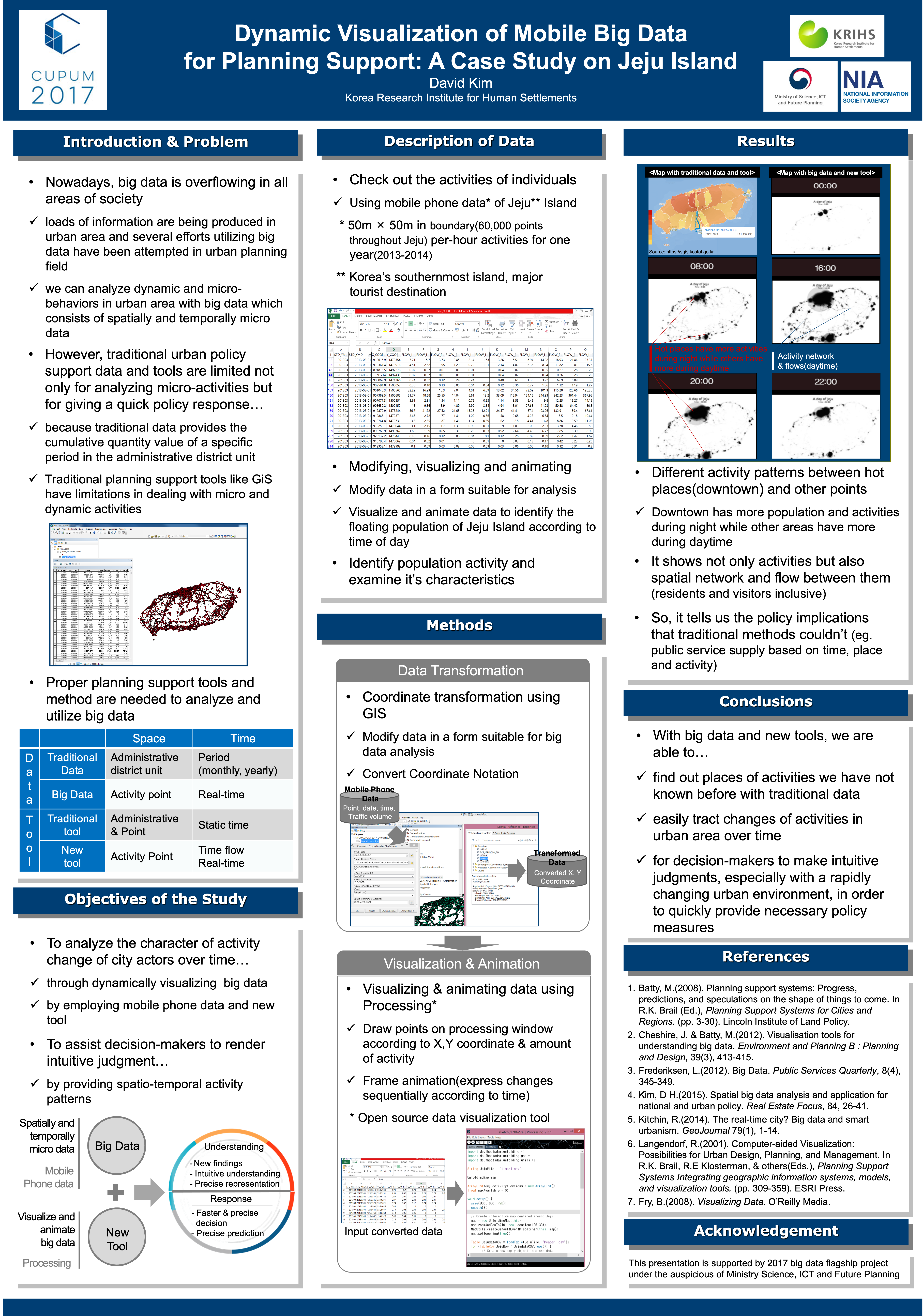
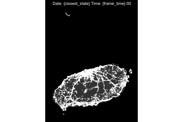
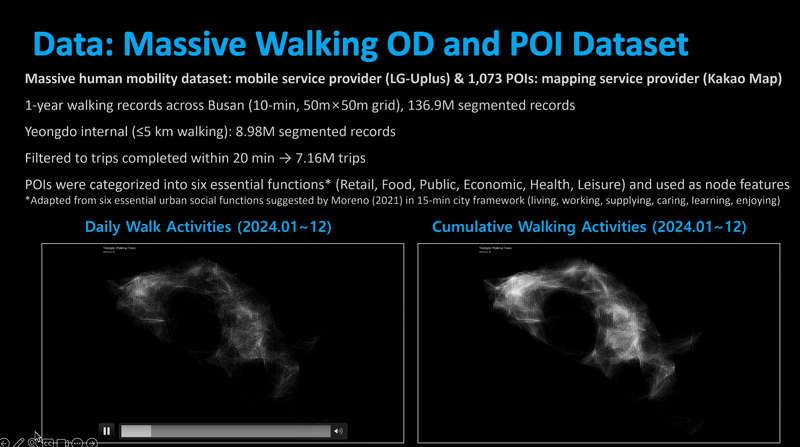
My primary methodological approach integrates GIS, network analysis, spatial visualization, and AI techniques to extract meaningful patterns from large spatial datasets. These datasets typically include points and zones (such as residential parcels and administrative boundaries), as well as network and flow data (e.g., navigation trajectories, mobile phone GPS data, card transaction records, and origin–destination vehicle flows). By applying these analytical techniques, I aim to transform raw spatial data into actionable knowledge that supports urban planning and policy-making related to land use, housing markets, social inequities, and urban safety. For illustrative examples, see Research Highlights below.
Experience
-
Associate Research Fellow
Korea Research Institute for Human Settlements
June 2019 - present
-
Researcher
Korea Research Institute for Human Settlements
Mar. 2012 - June 2019
-
Research Assistant
Colleage of Design, Construction, and Planning
University of Florida
Jan. 2021 - Dec. 2024
-
Project Consultant & Manager
Millennium Promise & Merry-Year International
Jul. 2011 - June 2012
Education
-
Ph.D in Urban and Regional Planning
University of Florida
Jan. 2021 - Dec. 2024
-
MS in Urban and Regional Planning
Seoul National University
Mar. 2009- Feb. 2011
-
Bachelor of Science in Urban and Environmental Engineering
Graduated first class honor, Handong Global University
Mar. 2002 - Feb. 2009
Technical Skills
- Languages: Python | R | SQL | Java | HTML
- Libraries & frameworks:
- Visualization: Mapbox.js | Processing
- Machine learning: PyTorch | TensorFlow
- Network anlaysis: Gephi | UCINET | NetMiner
- Spatial Analysis Tools: ArcGIS | ArcGISPro | QGIS | S-Cube
- Other software: SPSS | JMP
Interests
- AI&Big data-based planning support
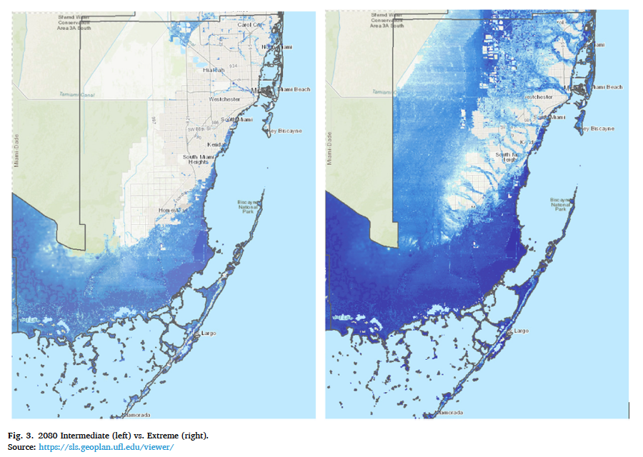
- Climate gentrification | Residential location & Housing market
- Geospatial analytics | Visualization | GIS
- Data science | Machine Learning | Computer vision
- Spatial Network analysis | Urban modeling and simulation